Manual
English
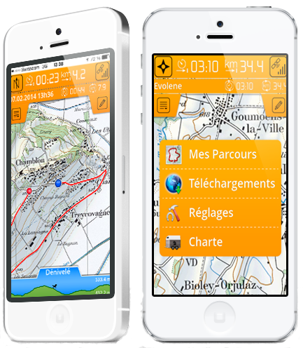
Horsetrails is a mobile application designed for horseback riders willing to record their preferred trails or discover new trails.
Trails and maps are stored on your device and work offline (no data connection necessary). You can use the application without GSM coverage or in a foreign country.
With just a click, you can record your trail. Once the trail is complete it is stored on your phone and you can share it by email with your friends or through our public database on our Horse trails web platform (available soon) to share it with any other horse rider. You can comment your trail, define terrain type and/or rate trails published by others.
We offer free open source maps for the entire world (from openstreetmap.com) and free digital elevation data (for terrain profile along the trail). We also offer commercial maps such as topographic maps and aerial images (satellite photos). Once downloaded maps are stored on your device and you don't need internet connectivity to use them (unlike many other map applications).
Are you willing to know the time, distance and elevation of the trail before starting it? We display all the information in the top bar and bottom elevation profile of the application.
Open a free account on our horsetails platform to access trails shared by other horse riders. Share your own favorite trails.
Along your trails, take photos of points of interest and find them on the map at the location where they were taken.
Official or recommended trails are available for download free of charge or for a minimal fee.
 Parcours Equestres Conseillés du canton de Vaud (AVIC-PEC)
Association des Cavaliers de la région Arve et Lac (ACAL)
Réseaux équestre d'Equivia (Fribourg)
Les sentiers équestres d'Attalens (Fribourg)
Trail of CDTE Auvergne
Trail of Pays Sancerre/Sologne
Trail of CDTE 44
Trail of l’Ain à Cheval
Trail Equirando à Lignière (CHER)
Trail Equi’Sioule (Val de Sioule)
Trail of CDTE 64
Trails of CRE of Limousin
Trails of CRE of Alsace
Trails of CRTE of Lorraine
Trails of Grands lacs de Champagne and Forêt d'Orient's area
Trail of Ile et Vilaine
Trails of l'Association Wallonne de Tourisme Equestre
Trails of Centre Européen du Cheval
Parcours Equestres Conseillés du canton de Vaud (AVIC-PEC)
Association des Cavaliers de la région Arve et Lac (ACAL)
Réseaux équestre d'Equivia (Fribourg)
Les sentiers équestres d'Attalens (Fribourg)
Trail of CDTE Auvergne
Trail of Pays Sancerre/Sologne
Trail of CDTE 44
Trail of l’Ain à Cheval
Trail Equirando à Lignière (CHER)
Trail Equi’Sioule (Val de Sioule)
Trail of CDTE 64
Trails of CRE of Limousin
Trails of CRE of Alsace
Trails of CRTE of Lorraine
Trails of Grands lacs de Champagne and Forêt d'Orient's area
Trail of Ile et Vilaine
Trails of l'Association Wallonne de Tourisme Equestre
Trails of Centre Européen du Cheval
More trails will be added on a regular basis
Automatic map rotation to follow your orientation, horse rider’s policy, and many others. Check it by yourself :-)